
Data Import Essentials
Lexicon of terms
-
Geological Block Model: a Block Model populated with ore (raw material) and waste cells containing product grades (qualities) and other information. Air cells (voids) need not be present.
-
Product: metal or other mineral element that can be recovered from ore (raw material) and sold at a price. The Geological Block Model must define at least one product.
-
Attribute: a mineral element or any other data item that is relevant for mine planning, for example, to ore processing.
-
Density: a ratio of rock mass to rock volume.
-
Tonnage Factor: a ratio of rock volume to rock mass, the inverse of density.
-
Tonnage: the rock mass in tons or any other mass unit.
-
Ore Fraction: a cell or sub-cell fraction that is ore; the remaining part of the cell is assumed to be waste. This is commonly used by applications that do not support sub-cells.
Warning: Element grades (qualities) must be given relative to the effective ore tonnage, not the entire cell tonnage.
-
Ore Percentage: the Ore fraction (see above) multiplied by 100.
-
Indicator Data: data item taking integer values. Rock types, surface collections, slope regions are commonly defined by indicator data.
-
Mining Cost Adjustments (MCAF): on import, block specific multipliers applied to reference mining costs.
-
Processing Cost Adjustments (PCAF): block-specific multipliers applied to processing costs.
-
Reblocking: clustering sub-cells from a number of cells into a larger cell; process used to optimize block model size for long-term planning, see the note below.
-
Resource Category: the main resource classification field in the model. This will be used in the default dashboards. Only one field of this type can be specified during model import. Can be referred to in formulae, such as that used to process the economic model. A lease type could be one example of a resource category.
-
Categorical Value: one or more fields in the imported model representing categorizations (e.g. fields for custom reports. Can be referred to in formulae, such as that used to process the economic model. A categorical field could represent land ownership, for example.
Importing Data
Importing mine planning models and other data is simple. At each stage of the process, automatic reports are generated making data validation easy.
Mine planning models can be imported from a wide range of formats and mapping of the model’s contents to required data is straightforward.
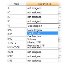
Field assignments are completed as part of model import. See Import Data: Quick Start.
Geological Model Fields
-
One Productfield is required; any number of product fields can be imported.
-
Attribute fields are optional; any number of attribute fields can be imported.
-
Density, Tonnage Factor and Tonnage fields all define cell (sub-cell) mass, so only one of the three can be imported. These fields are optional; if none are present, all cells will be assigned the same default density.
-
Ore Fraction and Ore Percentage fields define the same thing, so only one of the two can be imported. Element grades (qualities) must be given relative to the effective ore tonnage, not the entire cell tonnage. These fields are optional.
-
Rock Types field is optional; if present, rock types can be represented by indicator data (integer rock codes) or by word labels.
-
Slope Regions field is optional; if present, slope regions can be represented by indicator data (integer slope codes) or by word labels.
-
Up to two surface (pit) collections represented by indicator fields can be imported with the Geological Model. The pits must be represented by positive (nonzero) integer values; other values will be ignored. The two collections are referred to as “Mining Surface” and “Property Surface”.
-
Volume field is optional; this field is commonly used to import cell percent (or fraction) below topography fields. Volume cannot be imported in conjunction with Tonnage field (cell rock mass defined directly).
-
MCAF and PCAF fields are optional.
-
You can choose a single Resource Category. This field details the resource classes to be used during processing. This field can be referred to in formulae.
-
You can choose one or more Categorical Value fields. These fields represent the categories used during the optimization workflow, such as running a profit model. Can be used in formulae.
Using Legends
When your product loads or imports block model data, it will automatically generate a series of display legends that can be used to visualize various aspects of the model cells. These legends are accessible in multiple places, but can be easily accessed using the corresponding Block Model Properties dialog, for example:
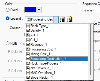
Your product will attempt to create default legends to highlight the following visual traits, each time a block model is loaded or imported:
- Rock Type, per process (when applicable)
- Imported Slope Region (when applicable)
- Each imported product
- Each imported attribute (when applicable)
- Density (when applicable)
- Mining Surface (when applicable)
- Economic model processing destination (including rock type-process) *
- Economic model profit (NPVPROFT)
- Optimized pit by LG phase
- Optimized pushbacks by pushback
- Optimized schedule by period
- Optimized MFO schedule by period
- Slope regions
* For each"Rock Type-Process" legend, the legend the colouring will be the same but different luminance for each process. For example, if you have Oxide and Sulphide rock types (and waste), and mill and leach processes for each one, the legend would have the following entries:
-
Oxide-Mill
-
Oxide-Leach
-
Oxide-Waste
-
Sulphide-Mill
-
Sulphide-Leach
-
Sulphide-Waste
-
Waste
Model Import Notes
-
One Product field is the only strict requirement; all other fields are optional.
-
The Product field may represent profit (block value), see Profit Model.
-
You can also import data like surfaces and outlines (digitized strings) independently of the geologic model.
-
Models with large numbers of small blocks (cells) are not appropriate for life of a mine planning. Ideally, the block height should be close to the real bench height while X and Y dimensions should be in the range of 10 to 40 meters. Reblocking preserves all original geological information; it neither averages or dilutes grades, nor mixes rock types. Reblocking affects the ultimate pit therefore exceeding the recommended block size may have negative impact on mine planning accuracy.