Transform Objects
To access this screen:
-
Run the command "georeference-objects"
-
Use the quick key combination 'gro'
-
Display the Find Command dialog, locate georeference-objects and click Run.
Transform the 3D location of any loaded 3D object using one or more pairs of point coordinates, using the Transform Objects screen.
Activity steps:
-
Ensure the data object(s) to be georeferenced are loaded (they do not have to be displayed, but it is recommended).
-
Run the command.
-
Select the object(s) using the upper list. These are the objects to be georeferenced. All selected objects are transformed.
-
Either use the pick buttons in the first table row to interactively select a location in the 3D view and its new georeferenced position. Alternatively, you can enter coordinates manually, or use a combination of these techniques.
-
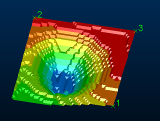
Add as many landmark and world coordinates using the "+" button and either pick or enter coordinates for each. As each coordinate is selected, it appears in the 3D view with a crosshair and point number (which matches the number in the table), for example:

-
If only a single point (current and target) is specified, a simple data translation occurs, that is, without rotation around any axis.
-
If two point pairs are defined, a translation is applied using the first point pair, followed by azimuth and dip adjustment to align the second point target.
-
If three point pairs are defined, the same transformation as for two points is applied, with a subsequent roll adjustment to honour the third target position.
-
If more than three point pairs are defined, a 'best fit' transformation is applied to adjust the data position and orientation as closely as possible to all target point locations.
-
-
Click Transform to relocate your selected object(s).
Related topics and activities

