Edge Editor
To access this screen:
-
Using the Design panel, select Manual Design >> Edge Editor.
The Edge Editor is lets you modify underground planning string design data in a 3D window.
Pick a string, then review its edge coordinate and orientation data, then edit accordingly and precisely. Data can be selected before or after the screen is opened. If string selection changes whilst the screen is displayed, its contents update automatically.
Strings can be edited on an edge-by-edge basis, or you can choose the point at which a transformation should start and then adjust all subsequent edges along the design string in the same way.
The currently selected string is represented in the main table with one table row representing one edge (an edge is the straight line between two string points).
Each string edge is defined in terms of its Length (Slope, Horizontal, Vertical), its Azimuth and its Gradient (Ratio, Percentage and Degrees).
Selecting a row in the table will highlight the corresponding string
edge in the 3D window, e.g.: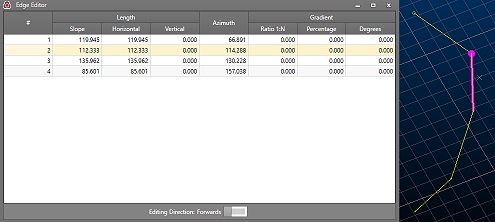
Once an edge is selected, you can change any or all of its edge definitions. Depending on which data is changed, this may affect neighbouring edge information.
To make an edit to any edge property, position the mouse over a row in the table, then edit a field, remembering to press <ENTER> after each change. String data will update automatically in the 3D window as changes are made.
By default, edge properties are calculated from the start to the end of the edge. You can change this using the Edit Direction toggle at the bottom of table. This will automatically update the values in the table to reflect the new direction of measurement.
|
|
Related Topics |
|
|
The Design PanelEdit Attribute Definitions |