Drillhole Sections
The Section Template
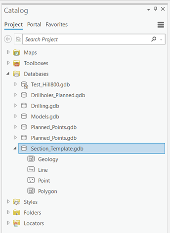
The Section Template database (Section_Template.gdb) is located in the Catalog Pane under Databases and is saved in <ESRI Project Folder>\Discover_Drilling. Section templates can be created from scratch using the Section Template Manager.
Background
The Section Template functionality in Discover for ArcGIS Pro is one of its most powerful features. It significantly enhances productivity for users who work extensively with sections.
With the ability to generate sections, you can quickly create large volumes of data. This process benefits from consistent data formatting and styling across all sections, eliminating the need to configure settings for each new section individually. If you plan to export this data to 3D as a unified file set or to generate 3D multipatches from the section data, the Section Template automatically detects your desired data structure. It then consolidates the data into a single file within the 3D environment, based on the tables defined in the template.
Because Discover uses sections to generate 3D models, you must define the 3D model’s parameters before creating it to ensure consistency.
Architecture
2D sections
Discover for ArcGIS Pro uses ArcGIS Pro’s 2D map windows to represent each section. A section serves as a 2D view intended to generate high-level cartographic output. Since ArcGIS Pro cannot position a 2D map within 3D space, we must embed 3D metadata into each section. This ensures that when a section is transferred to the 3D environment, it is accurately placed in 3D space.
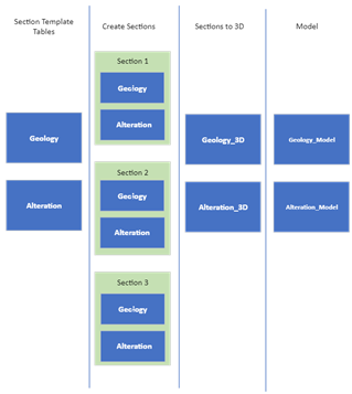
As a result, each section requires its own file. Instead of using a single table for an entire project, we maintain a separate table file for each section. For example, if the project includes a table named "Geology," then each section must have a corresponding geology table, such as Section1_Geology, Section2_Geology, and so on.
The Section Template automatically generates these tables when new sections are created. It also has the ability to merge all individual section tables into a single unified table (Geology_3D) when the sections are imported into the 3D environment. In 3D, this consolidated table ensures consistent attributes and styling across all sections.

Tables
A Section Template can manage an unlimited number of feature classes, including points, lines, and polygons. These feature classes are stored in the Section_Template.gdb, a dedicated geodatabase that is maintained as part of the project’s database.
You can access these tables through the Catalog window, as shown below. The geodatabase is automatically generated when you create a Discover Drilling Project and includes three default feature classes: point, line, and polygon. If these defaults are not required, you can manually remove them from the Section_Template.gdb.
All feature classes created using the Section Template are saved in the Section_Template.gdb, where you can manually add or delete them as needed.

Styles
You can link styles to the Section Template. When a section is generated, each unique value within a table can be assigned a specific style. If a style is not linked to a value in the section template’s feature layer, ArcGIS Pro applies a random color scheme.
To ensure consistent styling across all sections, it is recommended to use the Apply Symbology tool on your Section Template. Alternatively, you can use the Legend to Template tool.
Styles are stored as ESRI Layer (.lyr) files in the following directory:
<Project_Folder>/Discover Drilling/<Table_Name>.lyr
Additionally, a <Table_Name>_MP.lyr file is provided to define the color styling for multipatches.
Creating a Section Template
The easiest way to create a Section Template from scratch is by using the Legend to Section Template tool. This method is recommended because the Legend Editor can efficiently generate all the required unique values for styling in a single step.
Note: The Discover legend does not support gradients or other advanced styling options available directly in ArcGIS Pro. However, you can refine these styles within a generated feature layer and then apply them to the Section Template using the Apply Symbology tool.
You can also generate section template tables by creating a table within the Section_Template.gdb. Then, create a list of distinct values for a table by using a domain within the Section_Template.gdb. Link this to the table using the field design functionality. If necessary, include this feature class in a map and style the unique values imported from the associated domain. Subsequently, you can create a feature layer from this and import it using the Apply Symbology tool.
You can also generate section template tables by creating a table within the Section_Template.gdb. To define a list of distinct values, create a domain within the same geodatabase and link it to the table using the field design functionality.
If needed, add the feature class to a map and style the unique values based on the associated domain. Once styled, you can create a feature layer from it and apply the symbology to the section template using the Apply Symbology tool.
Creating a Section from a Section Template
When you generate a section (see, Generate Vertical Sections), any table in the Section Template is duplicated in the Drilling.gdb as a feature class named <Section_Name_2D_Table_Name>. In this context, the table name refers to the name of the table in the Section Template.
For example, if the section template includes a polygon feature class named Geology, and you create a section named Section_1, a new polygon feature class named Section1_2D_Geology is created in the Drilling.gdb.
During section creation, ArcGIS Pro loads a 2D map named after the section. The generated feature class is also added to the map as a feature layer, styled with the symbology defined in the Section Template. Once the section is generated, you can easily annotate it using the consistently styled feature layers.

