Create Reference Codes for Grid Conversion Mapping
As indicated in Create Reference Codes for Grid Types, when using the CSMAP grid conversion method, the Defined status indicates whether grids can be converted. The conversion is handled with routines found in CSMap.dll. When using the CENTURY grid conversion method, you must configure conversion mappings for each grid.
To convert a grid:
- On the Home screen, select Maintain » Reference Tables » Grid Definitions » Grid Types from the menu.
The Grid Conversion Mapping window displays.
- On the toolbar, click New.
- Select the From Grid (the source coordinate system) and complete the following fields:
- Unit of Measure—The unit of measure of the source grid.
- Northing—The coordinates of the origin of the source grid, in the target's coordinate system.
- Easting—The coordinates of the origin of the source grid, in the target's coordinate system.
- Elevation—The coordinates of the origin of the source grid, in the target's coordinate system.
- Select the From Grid (the target coordinate system) and complete the following fields:
- Unit of Measure—The unit of measure of the target grid.
- Northing—The coordinates of the origin of the target grid, in the source’s coordinate system.
- Easting—The coordinates of the origin of the target grid, in the source’s coordinate system.
- Elevation—The coordinates of the origin of the target grid, in the source’s coordinate system.
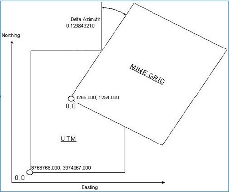
- Enter the Delta Azimuth value, which is the rotation angle between the two grids.
The image below illustrates the association between two grids and shows the information that is used in the conversion mapping.