
Create Polygon
This tool is designed to create a polygon file. A polygon file can be either 2D or 3D and may contain several polygons. This kind of file is mainly used for graphical purposes and/or to build selections. A polygon file is a structured file containing a Points data table and a Vertices data table.
Note: A 3D polygon is a 2D polygon with a thickness defined by a minimum and a maximum value for Z.
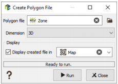
- Polygon File: Click the directory icon to open a Data Selector and define the name and location in your Isatis.neo project of the new Polygon File you want to create. If the polygon already exists, it will be overwritten.
- Dimension: Choose the dimension of your new polygon file, 2D or 3D. Be careful as a 2D polygon file cannot contain any 3D polygons and vice versa.
-
The new created polygon file is empty. The following step consists in interactively digitizing the polygon contours in the Map using the different available tools. In this way, by ticking the Display toggle and selecting a scene, the layer associated to your polygon file will be automatically added in the corresponding scene at the end of the run. The polygon can also be visualized in a 3D scene but the 3D Viewer does not allow any manual digitization.
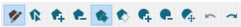
Note: For more information about the different tools available for polygons digitization, please see the dedicated section in the Map Window Tool Bar.
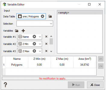
If the created polygon is in 3D, the minimum and maximum values of Z should be defined by using the Variable Editor tool. Edit and modify the Z Min and Z Max variables (contained in the Points data table) to enter the corresponding elevation. Vertices coordinates can also be modified through this tool to be more precise than the points you digitized.
- Click Run to create the polygon. The polygon will be directly visible in the Data tab.