
Create Polyline
This tool is designed to create a Kriging. A polyline file is a structured file containing a Points data table and a Vertices data table.
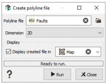
- Polyline file: Click the directory icon to open a Data Selector and define the name and location in your Isatis.neo project of the new Polyline file you want to create. If the polyline file already exists, it will be overwritten.
- Dimension: Choose the dimension of your new polyline file, 2D or 3D. Be careful as a 2D polyline file cannot contain any 3D polylines and vice versa.
-
The new created polyline file is empty. The following step consists in interactively digitizing the polyline contours in the Map using the different available tools. In this way, by ticking the Display toggle and selecting a scene, the layer associated to your polyline file will be automatically added in the corresponding scene at the end of the run. The polyline file can also be visualized in a 3D scene but the 3D Viewer does not allow any manual digitization.
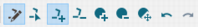
Note: For more information about the different tools available for polylines digitization, please see the dedicated section in the Map Window Tool Bar.
- Click Run to create the polyline file. The polyline file will be directly visible in the Data tab.