
Read PDAL Data
To access this dialog:
-
After selecting a PDAL-supported points file, the Read PDAL Data dialog is automatically displayed.
This screen is displayed as part of points file import using a driver in the Common Point Clouds Driver Category. It is displayed once a file has been selected, but prior to the actual import of data.
Input sample points files from geological domains can often contain far more points that you need for modelling or other analysis. The Read PDAL Data dialog allows you to filter the incoming points data in one of the following ways:
- Reduce the density of points in Studio in relation to the number of points in the input file.
- Reduce the number of data attributes that are imported into Studio.
Note: As a general rule of thumb, which can vary significantly with hardware, incoming point file size and format, the PDAL reader can import/process approximately 1m points every 8-10 seconds.
Activity steps
- Review the file summary information.
- Filename
- Number of Points - the original number of points in the file, prior to declustering.
Projection - the current projection of the data (if present) in OpenGIS Well Known Text (WKT) format.
- To decluster point data on import:
- No Declustering: import all points. This can, for large files, significantly extend the importing time and generate a very large object in memory.
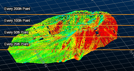
Ratio Based Declustering: Set a Target Point Number for the loaded data object. The total number of points (N) will be divided by the target (T) to achieve a ratio (N/T = Z, use every Zth point during loading).
For example, if the input file contains 20,000,000 points and the target is 1,000,000, the import routine will only import every 20th point (20,000,000/1,000,000 = 20). :Note: Target Point Number is a guideline; the declustering process will not eliminate precisely every Nth point as removal will actually depend on the clustering of the data within the file. It should, however, result in a file containing approximately the target.
Grid Based Declustering: Decluster so that only point is permitted in each cube of a 3-dimensional grid applied over the hull of the imported data. This size of the grid can be controlled. This option will tend to remove more data in denser areas than sparser areas and can result in a more evenly-distributed points file in memory.
Note that declustering will only remove points, it will not introduce them.
With this option, the amount of declustering performed is inversely proportional to the Grid Size : a larger grid size is likely to trigger a more significant reduction of the number of points that are imported, although this will depend on the nature of the points file being imported.
- Choose the Attributes to Import. All non-system attributes are listed. System
attributes, such as positional information required to construct a
Datamine points file, will always be imported.
If RGB color information is detected, these attributes will be selected by default and used to construct a color legend in Studio products. - If importing a file to a Studio project, the Import Files screen displays.
-
Use the Import Files screen:
-
Choose which Files to create and associate with your project.
-
Confirm the Import Fields for this operation.
-
If required, choose how to Rename Fields during import.
-
Click OK.
Files references are added to the project.
-