query-lines ("ql")
See this command in the command table.
To access this command:
-
Map ribbon >> Query >> Measure
-
Using the command line, enter "query-lines"
- Use the quick key combination "ql".
-
On the Find Command screen, highlight query-lines and click Run.
Command Overview
Calculate statistics for a line interactively defined by two end points.
This command honours current data selection
and snap settings. Points that are selected using left-click
(no snapping) in any 3D
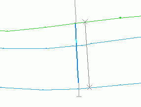
As an example, querying the line, snapped to
the two strings shown below (ore body section strings and
drillhole data) :
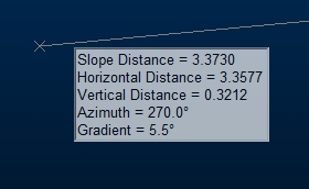
If cursor tooltips are enabled, summary information is displayed on screen at the cursor location, after the first point has been digitized:

You can click and hold/drag the second point to dynamically update cursor tooltip information as the cursor moves.
-
If the line is horizontal - only horizontal distance is shown (plus azimuth and gradient).
-
If the line is vertical - only vertical distance is shown (plus azimuth and gradient).
-
Otherwise slope, horizontal and vertical distance are shown.
Command steps:
-
Run the command.
-
Select (left or right-click) the line's first point.
-
Select (left or right-click) the lines second point.
-
Check the position of the grey query line and the associated statistics in the Output control bar.
Displayed statistics include:
-
X, Y and Z coordinates of each of the end-points
-
X, Y and Z Difference between the second and first points
-
Slope Distance, Horizontal Distance and/or Vertical Distance between the two points
-
Azimuth (direction) of the line in degrees
-
Gradient of the line in degrees, 1:X and %.
-
Related topics and activities

