
Activate the GPS Connection
To start listening the GPS, go to the Map window and click ![]() . The GPS dialog box will pop up:
. The GPS dialog box will pop up:
- COM Port: Select the correct Communication Port (COM1, COM2...) on which the GPS is connected.
-
Select the Baud Rate (4800 or 9600 baud).
Note: Each time you connect a GPS (by USB or Com Port), the operating system attributes the free COM Port with the lowest number to the GPS. Usually it is COM3 or COM4. For more details go to the GPS COM Port section.
-
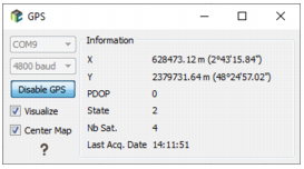
Click Enable GPS to start listening the GPS. Then you will see in the Information box the status of your GPS with value of:
- X: Coordinate along X axis of the coordinate system of the project.
- Y: Coordinate along X axis of the coordinate system of the project.
- PDoP: Corresponds to the quality of the signal. The scale goes from 0 to 20, 0 corresponding to the best quality and 20 to the worst. This value depends on the quality of the GPS and whether the device is used inside or outside.
- State: This is a code which informs you on the status of the GPS.
- Nb Sat.: This value corresponds to the number of satellites used by the GPS to determinate the location. At least 3 satellites must be used to produce a correct value.
- Last Acq. Date: This is the last date when the GPS location has been recorded in the acquisitiondatatable.
-
Select the Visualize option to see the GPS location on the Map window. A blue point is used as symbol
 .
.
- Select the Center Map option and the Map window will keep focus on the GPS location.
- Click Disable GPS to stop the GPS connection.