
Data Types you Import into Isatis.neo
This chapter describes which types of data you can import into Isatis.neo and from which file formats and software products:
-
CSV/Excel: CSV files or Excel files (.xls, .xlsx) are supported and enables you to import 2D/3D points, boreholes or 2D/3D gridded data into Isatis.neo.
The loading procedure is divided into 5 steps:
- Import Mode: You have here to choose how your data set will be imported. There are three possibilities: Create a New File, Add Variables in an Existing File or Add Samples in an Existing File.
- Input CSV/Excel Files: This page allows you to select the imported file(s). If you import boreholes, you have to consider several files, one for each support (tops, surveys, assays). If your boreholes information is contained in an Excel file, the selected input file can be the same, but the information related to each support should be stored in different sheets.
- File Decoding: This page allows you to check your files are correctly read. You should define the way your CSV files are organized or choose which sheet of your Excel file you want to import.
- Variables Definition: This page enables you to define the variable properties (their name, role, unit class and unit, undefined values) of each input file. Please go to Types of Variables to see more information about the variable roles.
- Summary: This last page sums up the variables definition for each input file. It enables you to choose where your data set will be imported in the Isatis.neo database and to potentially display them in a 2D/D defined scene at the end of the import.
- ODBC: Points and boreholes data stored in ODBC databases such as Microsoft Access, acQuire, MaxGeo Datashed, Microsoft SQL Server (MSSQL), or PostgreSQL can be imported.
-
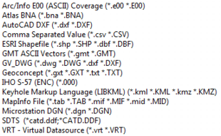
OGR: This import uses the OGR library enabling the import of vector files: points, polygons and polylines. All the supported formats are listed in the snapshot just below. Only geometry and object names are imported, not the file attributes (i.e. the variables contained in the file).
- Gocad: Polylines and polygons can be imported. Only geometry and object names are imported, not the file attributes (i.e. the variables contained in the file). This import enables the creation of a new file or to overwrite or append new objects in an existing file.
-
Isatis GTXserver: This application is meant to directly import data from an Isatis study into an Isatis.neo project using the GTXserver.
The GTX Server Settings button allows you to:
- Run GTX Server: in that case Isatis.neo will automatically launch the GTX Server associated with Isatis. Click on Specify GTX Server executable if you want to give the path for the GTX Server.
-
Use existing GTXserver instance: in that case you have launched manually the GTX Server and you need to specify the Host Name and the Port where it is running so that Isatis.neo can identify it. Enter a Data Path, if the study list you want to use is not the one by default in Isatis.
This import can deal with 2D/3D points, 2D/3D grids, boreholes (3D lines), 3D meshes (wireframes of Isatis) by creating a new data table in Isatis.neo. Points and boreholes can also be added to an existing data table of this type and variables can be appended to grid data tables.
- Vector file: This import enables the loading of vector files (*.shp, *.dxf,...), points, polygons or polylines. Only the geometry of the file will be consider, not the potential variables associated.
- Datamine: This import is designed to load Datamine points, boreholes, grids, meshes (triangle files), polygons and polylines into Isatis.neo. Mesh import requires the definition of two files: a wireframe points file (xxxpt.dm) and a wireframe triangle file (xxxtr.dm).
- Gocad: This import is designed to load polygons and polylines into Isatis.neo.
- Raster file: This import is designed to load raster geospatial data (i.e. 2D grid files) from GDAL-supported files (including Z-Map, Arcview, GeoTiff, netCDF formats).
- CAD (DXF, DWG, STL, OBJ, OFF): This import enables the loading of surfaces or volumes mesh files. Only geometry and object names are imported, not the file attributes (i.e. the variables contained in the file).
- Leapfrog: This import is designed to load meshes with the extension .msh.
- acQuire: This import is designed to load boreholes.
- Irap: This import is designed to load 2D grid files with an elevation.
- LASv2: This import is designed to load wells with logs.
- CPS3: This import is designed to load 2D grid files with an elevation.
- Vulcan: This import is designed to load drillholes (raw samples, desurveyed holes or composites), block models or meshes (triangulations) files.
- SEG-Y: This import is designed to load seismic data from a seismic cube stored in a SEG-Y binary file.
- Eclipse: This import is designed to load regular and irregular grid from Eclipse files (with .grdecl extension).
- Petrel: This import is available through a plugin in Petrel and enables the loading of markers, surfaces, horizons, grids, and fault sticks to Isatis.neo.
Each import task offers a Coordinate System Selector if your project has not been created in a local coordinates system. It will defined the coordinates system of your imported file(s). If this one is different from the coordinates system of your project, data will be automatically reprojected.
Three import modes are available (but not for each import and not for each type of data):
- New File: Use this mode if you want to import a complete data set with coordinates. Then simply choose a new Isatis.neo data table in which to store your data.
-
Add New Variables in an Existing File: Merge data by adding some new variables to an already existing Isatis.neo data table. The principle is that the organization of this appended data is identical to the one of the initial data file (in other words, the samples are the same). This is particularly true for the grid data tables. You should pay attention to the order of the samples stored in the file.
If a variable already exists in the first set, it will be replaced by the new values of the second set.
This mode enables you to enter datasets containing a large number of variables which would not fit in one single file (remember that all the variables corresponding to one sample must be present on one single record of the input file).
-
Add New Samples in an Existing File: Add new samples to Points or Boreholes structures (of course, it is not possible to add samples to Grid data tables).
If a variable already exists in the initial Isatis.neo data table, the value of this variable will just be added for the new samples. If a new variable is declared in the second file, this variable will be first created then set to undefined value for all the samples already existing until the new values are read from the appended file. In the same way, variables of new samples will be created and set to undefined values until the old samples and their values are read from the existing data table.