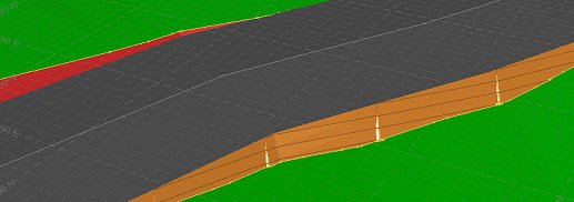
Update Topography

The Create Surface Roads screen is used to create roads on a reference topography, using a reference line and various parameters describing road profile and cut and fill batters.
After running the command, the Create Surface Roads dialog is displayed in a dockable control bar.
When road and batters have been generated and look as you want them, the Update Topo button can be used to create a copy of the original topography.
The topography is updated to incorpote the designed road (honouring the cross sections specified), connected to the topography via cut and/or fill batters. A continuous surface is created, with each element of the topography (with respect to surface roads) being shown in a separate colour.
The resulting wireframe object will include a TYPE attribute containing the following possible values:
- Absent (-): surface representing the original topography
- ROAD: surface representing the designed surface road
- CUT: surface representing a batter cut surface
- FILL: surface representing a batter fill surface
If the original topography is being shown in the current view then it will automatically be hidden. You can re-enable it using the Surface Roads Toolbar if you wish.
Related topics and activities

