
Map Properties
To access this panel:
-
The Map Properties panel is part of the Mapping task bar.
Map properties are either editable or read-only. Some properties are configured for your organization (via your System Configuration file). These can be editable or read-only, and can be populated with valid values. You can even make the contents of one list depend on the values of another.
There are also 'calculated' fields, such as a field to show the dominant lithology for a face map, or the average face grade, and so on (see "Evaluated Map Properties", below).
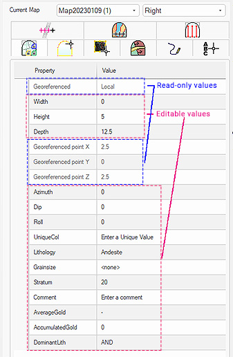
An example of a Map Properties screen for a face map
Face Map Properties
Face Map Size
You can edit the height, width and (if relevant) the depth of a face map after it has been created. It will be automatically resized. Note that depth values are only relevant for non-orthogonal faces such as the floor, roof, left and right side walls. Width and Height must be greater than zero but Depth can be zero or higher.
You can access the Map Properties panel for the active map at any time. It shows the values associated with the current map, regardless of the face selection.
For level maps, you can also adjust the map boundaries (X Min, X Max...) providing the Auto-calculate bounds setting is not active. If it is, the bounds of the map are dictated by the loaded survey data extents. See Level Map Survey Data.
Tip: If you are using a portable device, automatically display a screen keyboard for easier data entry at the face. Enable screen keyboard mode using the Setup ribbon's On-Screen Keyboard command.
Azimuth, Dip and Roll appear for face maps represent your map's orientation settings. You can edit these if you want a custom map orientation or need to refine a georeferenced map position.
Note: only Azimuth appears for a level map, which is always horizontal.
Evaluated Face Map Properties
Map properties can also be calculated based on the contents of the current map. You can currently generate dominant, average and accumulated results for any field name that can be found on the Features panel for the selected map. Evaluation map properties can be included in output reports.
There are plenty of potential applications for evaluated map properties. For example, you could automatically calculate the average AU grade of a face based on the current map feature polygon assay value assignments.
Evaluated map properties can be defined as DOMINANT, AVERAGE (numeric fields only) and ACCUMULATED (numeric fields only). Evaluations for the map will be performed across all available feature objects and faces. Evaluations are dynamic, any changes to the attribute value or (In the case of polygonal evaluation) shape changes are instantly reflected in the Map Properties panel.
Evaluated map properties are configured using your system configuration file.
Another example is reporting the dominant classification of the heading, based on area-weighted dominance of either waste or ore assignment as described by polygon objects on all faces of the heading. Waste assignment is shown in red, below, whilst ore is shown in Cyan. The Feature object attribute TYPE contains either absent, 'ORE' or 'WST' values. An evaluated map property (DominantType) is configured to display the dominant attribute value:
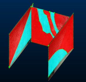
The waste material dominates this heading, so the Map Properties readout is:

A different scenario, like the one below, would give a different evaluation result:


A map can be supported by any number of properties, and an optional weighting field can be specified. Default weighting options can also be defined (again, via your configuration file) such as _AREA and _LENGTH.
Evaluation properties are recalculated when the any of the following events occur:
- The Map Properties panel is displayed.
- A report is generated.
- Any data is saved.
Find out More!: More information on this subject can be found on the Datamine Support Website. Contact your local Datamine office if you don't have access.
Georeferenced Face Maps
All maps, whether georeferenced or otherwise, have an origin. This is a position in local coordinates, (e.g. for a 5m x 5m single front face, the point is located at 0, 2.5, 2.5) or the world coordinates set during georeferencing.
Once a face map has been georeferenced (by any method), its Georeferenced property changes from [Local] to [World], and the Georeferenced point X/Y/Z properties show the current world coordinates of the map origin point (which may be on or off the map in 3D space).
You can edit the 3D position of the georeferenced point for any map using the Center of Rotation command. This location will be used as an anchor point when making map adjustments.
Tip: As a control bar, the Mapping task bar can be repositioned anywhere on the screen, and set to automatically hide if not in use. For more information on editing your user interface, see Customizing Control Bars.
For face maps, the Georeferenced property is either Local (not georeferenced yet, and only visible in a Map view), or World, meaning georeferencing has been applied (so is potentially visible in either a 3D World or Map view). Depending on this setting, the Georeferenced point X/Y/Z fields below contain local or world coordinates.
Note: for level maps, the Georeferenced property is always World as level map data is digitized in world coordinates, in relation to reference data. Wirefame maps are also always world-georeferenced.
Level Map Properties
If a level map is loaded, the following properties are available, in addition to any custom properties set in your configuration file:
-
Auto-calculate bounds—if enabled, map dimensions are dictated by the extents of loaded survey data and the map extents can't be modified manually. If disabled, the dimensions can be configured (see below).
-
X Min, X Max, Y Min, Y Max—these properties define the outer extents of the level map. These are editable only if Auto-calculate bounds is inactive (meaning the map dimensions are dictated by the extents of loaded survey data).
-
Reference Z—the elevation of the level map section. This should be close to the mean elevation of your loaded survey data.
Wireframe Map Properties
Wireframe maps are always world-oriented, although it is possible to re-orient them using other Studio packages. Generally, the properties that appear when a wireframe map is loaded are of the custom type and dictated by your system configuration file.
Custom Properties
Custom items on this panel rely on the contents of your system configuration file and can apply to any map type. This configuration also determines the values you can set for each custom attribute. For example, a Lithology attribute can be configured to accept only valid values from a drop-down list, and cannot be empty. Similarly, a Grain_Size attribute may accept only numeric values from 0 to 100, and so on.
See Assigning and setting up a configuration file.
Related topics and activities